
Roseburg Records Nearly Half an Inch of Rain Sunday as Wet, Cooler Weather Continues This Week
Roseburg recorded 0.47 inches of rain Sunday, Oct. 25, ending a lengthy dry stretch. More rain is expected Monday and Tuesday, with highs in the upper 50s, chilly overnight temperatures, and additional shower chances later this week.

ROSEBURG, Ore. - After several weeks of predominantly dry weather, Roseburg received nearly half an inch of rain Sunday, Oct. 25, as a series of weather systems began moving through Southern Oregon. More rainfall is expected Monday and Tuesday, with cooler temperatures and additional chances for showers continuing into the weekend.
According to preliminary National Weather Service climate data, Roseburg recorded 0.47 inches of precipitation Sunday, making it the first day of the month with measurable rainfall beyond a trace at the reporting station.
The rainfall follows an unusually warm stretch earlier in October. Temperatures in Roseburg reached 89 degrees on Oct. 16, well above normal for the season. Just over a week later, the area is experiencing a noticeably different weather pattern, with afternoon temperatures expected to remain in the upper 50s for much of the coming week.
The National Weather Service in Medford said a persistent area of low pressure over the Pacific Northwest will bring seasonably active weather through at least Saturday, although widespread significant impacts are not anticipated.
More Rain Expected Monday and Tuesday
Rain will remain the primary weather concern in Roseburg as the new week begins.
The National Weather Service forecasts rain mainly before 5 p.m. Monday, with a high temperature near 59 degrees. Southwest winds of 5 to 9 mph are expected, and the chance of precipitation is 80%.
Rain is likely to return Monday evening, mainly after 5 p.m., with overnight temperatures falling to around 43 degrees. The chance of precipitation is 60%.
Tuesday will bring another round of rainfall, primarily before 2 p.m. The chance of precipitation is 80%, although additional rainfall amounts are expected to be relatively light, with less than a tenth of an inch possible during the daytime period.
Tuesday's high is expected to reach approximately 59 degrees before temperatures fall to around 38 degrees overnight.
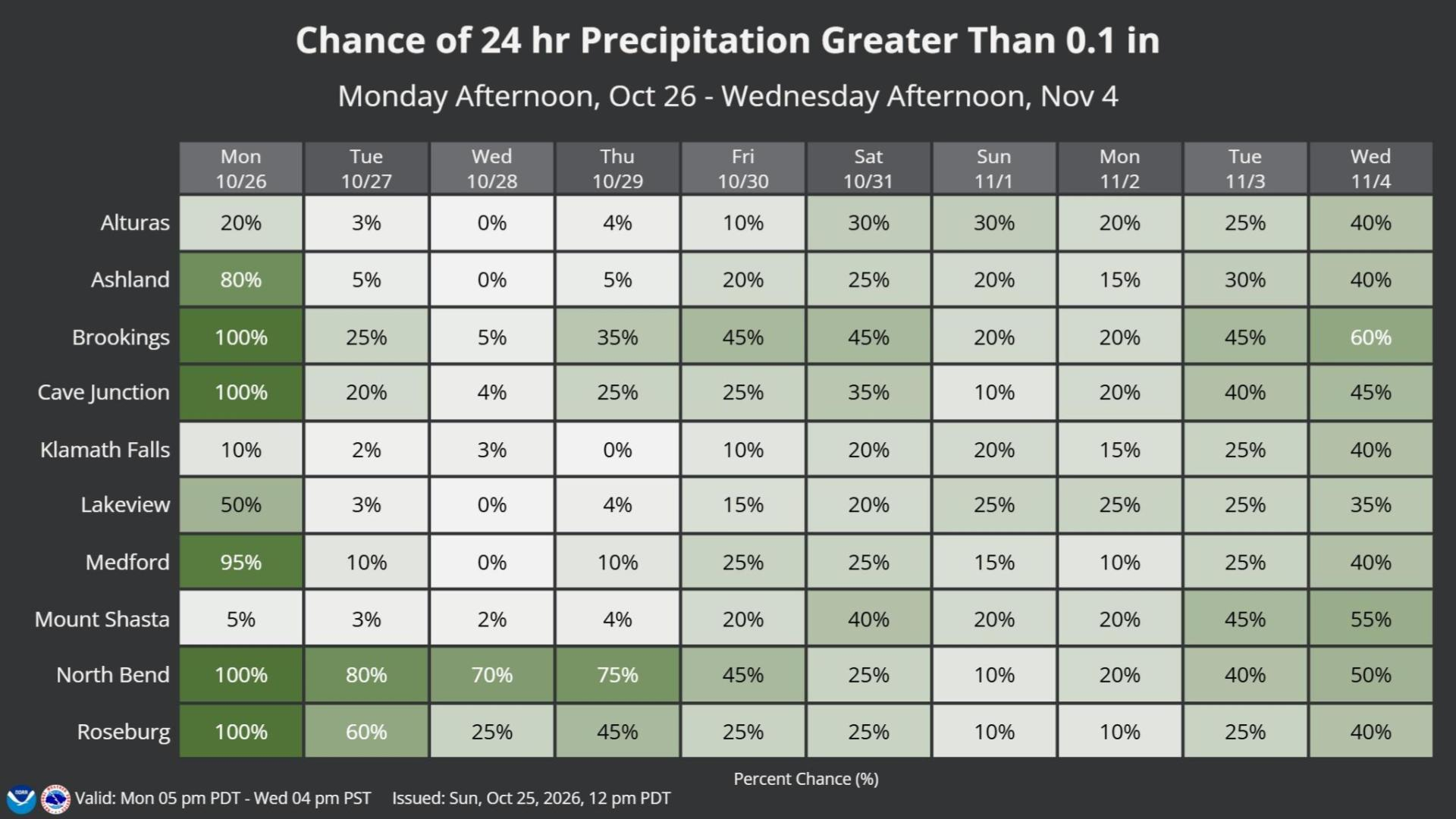
The National Weather Service's longer-range precipitation outlook also shows a 100% probability that Roseburg will receive more than one-tenth of an inch of precipitation during the 24-hour period ending Monday afternoon, followed by a 60% probability for the period ending Tuesday afternoon.
These probabilities reflect the chance of exceeding a specific rainfall amount during each 24-hour period, rather than the chance of any rainfall occurring.
Cooler Temperatures and Intermittent Showers Through the Week
Conditions are expected to improve somewhat by Wednesday, although additional showers remain possible.
Wednesday's forecast calls for a 40% chance of rain during the morning, followed by partly sunny skies and a high near 59 degrees. Overnight temperatures could drop to around 38 degrees.
Another opportunity for rainfall arrives Thursday, when forecasters predict a 50% chance of rain, mainly after 11 a.m., and a high near 57 degrees.
Friday and Saturday currently look drier in Roseburg, with mostly sunny skies and afternoon highs around 57 to 58 degrees. Overnight temperatures could fall into the mid-30s, with lows near 36 degrees Friday night and 35 degrees Saturday night.
Sunday is forecast to be mostly sunny with a high near 61 degrees, although the broader regional outlook remains uncertain as meteorologists continue tracking the position of low pressure offshore.
The National Weather Service noted that the exact location and movement of the weather system could influence how much additional rain reaches western Oregon later in the week.
Douglas County Could See Additional Rainfall
Although the heaviest and most widespread rainfall is expected early in the week, Douglas County remains one of the areas most likely to experience additional showers as the weather pattern continues.
Forecasters expect precipitation chances from Wednesday through Saturday to be concentrated primarily across Coos and Douglas counties and areas farther north.
The National Weather Service's extended outlook indicates that Roseburg has a 45% chance of receiving more than one-tenth of an inch of rain during the 24-hour period ending Thursday afternoon. Those probabilities fall to 25% for Friday and Saturday, before dropping to 10% Sunday and Monday.
Farther west, coastal communities could experience a longer period of wet weather. North Bend has a 70% probability of receiving more than one-tenth of an inch of precipitation during the 24-hour period ending Wednesday afternoon, compared with 25% in Roseburg.
Forecasters emphasized that rainfall timing and amounts later in the week remain subject to change.
Snow Possible Around Diamond Lake and Crater Lake
While Roseburg and much of the Umpqua Valley will experience rain, higher elevations in Southern Oregon could receive accumulating snow.
Snow levels are expected to range from approximately 5,000 to 5,500 feet early in the week, with around 2 to 5 inches of accumulation possible in the Diamond Lake and Crater Lake areas.
A second, weaker weather system moving through Monday night and Tuesday morning could lower snow levels to around 4,700 feet and produce up to an additional 2 inches of snow in those areas.
Later in the week, snow levels could drop to around 4,000 feet, occasionally reaching 3,000 feet as cooler air settles across the region.
However, forecasters do not currently expect widespread winter weather impacts because precipitation is anticipated to be limited during the colder periods.
Motorists traveling through higher elevations, particularly around Diamond Lake and Crater Lake, should remain aware of changing road conditions.
A Noticeable Shift From October's Warm Weather
The change in weather marks a substantial departure from the warmer conditions experienced across Roseburg earlier this month.
Climate records show Roseburg reached 86 degrees Oct. 5, 83 degrees Oct. 6, and 89 degrees Oct. 16. The city has since experienced cooler afternoons, including a high of just 62 degrees Friday, Oct. 23.
Sunday's rainfall also brought a notable change after a lengthy stretch without significant precipitation recorded at the station.
The National Weather Service expects daytime temperatures across western Southern Oregon to remain generally 10 to 15 degrees below normal for portions of the week, with highs commonly reaching the mid-50s.
Despite the unsettled conditions, meteorologists characterize the overall weather pattern as beneficial, bringing needed rainfall to western Oregon with relatively limited impacts expected.
For Roseburg, the week ahead will feature occasional rain, cooler afternoons, chilly mornings, and some opportunities for sunshine as the region settles into a more typical late-October weather pattern.



Comments ()