
Red Flag Warning Issued Wednesday for Roseburg and Much of Southern Oregon
A Red Flag Warning is in effect from 2 to 9 p.m. Wednesday for Roseburg and much of Southern Oregon. Gusty winds, humidity as low as 8%, and unstable conditions could cause fires to spread rapidly.
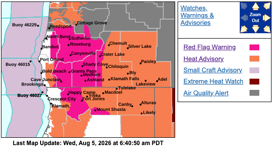
ROSEBURG, Ore. - A Red Flag Warning remains in effect Wednesday afternoon and evening for Roseburg and a large portion of Southern Oregon as strong, gusty winds combine with extremely low humidity and increasingly unstable conditions.
The National Weather Service in Medford said the warning will be in effect from 2 p.m. to 9 p.m. Wednesday, Aug. 5.
Forecasters said northwest to west winds of 10 to 15 mph are expected, with gusts reaching up to 25 mph. Minimum relative humidity levels could fall between 8% and 15%.
The combination of dry fuels, low humidity and gusty winds could cause any new fires to spread rapidly. Increasing atmospheric instability could also contribute to more active fire behavior on existing incidents.
The warning covers several fire weather zones across Southern Oregon and Northern California. Oregon communities and locations included in the warning area include Roseburg, Elkton, Tiller, Toketee Falls, Grants Pass, Medford, Ashland, Cave Junction, Shady Cove, the Siskiyou Mountains and the Southern Oregon Cascades.
The affected area also includes the Castle Fire northeast of Tiller and the East Evans Creek Fire.
Northern California locations covered by the warning include Happy Camp, Etna, Fort Jones, Mount Shasta City, Dunsmuir and McCloud.
A Red Flag Warning does not mean a wildfire is currently burning in every affected community. It indicates that weather conditions could allow a fire to ignite easily, spread quickly and become difficult to control.
Residents are urged to follow all current fire restrictions and avoid activities that could create sparks. People should also make sure they are registered for their county’s emergency alert system, review evacuation plans and have multiple ways to receive information from emergency officials.
Information about local fire restrictions and county emergency alert systems is available at https://weather.gov/medford/wildfire.
A detailed map of the warning area can be viewed at https://weather.gov/wrh/hazards?wfo=mfr.

Comments ()