
Red Flag Warning Issued for Umpqua Basin and Southern Oregon
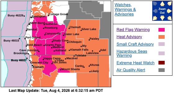
A Red Flag Warning is in effect Wednesday afternoon and evening for the Umpqua Basin and Umpqua National Forest. Gusty winds, very low humidity and unstable conditions could cause any new or existing fires to spread rapidly.
ROSEBURG, Ore. - Critical fire weather conditions are expected across much of southwest Oregon as hot, dry and increasingly unstable weather combines with low humidity and gusty winds.
The National Weather Service in Medford has issued a Red Flag Warning for the Umpqua Basin and Umpqua National Forest from 2 to 9 p.m. Wednesday, Aug. 5.
The warning includes Roseburg, Elkton, Tiller and Toketee Falls, along with areas near the East Evans Creek and Castle fires. Portions of Siskiyou County in Northern California are also included.
Forecasters expect west to northwest winds of 10 to 15 mph, with afternoon gusts reaching 25 mph. Minimum relative humidity could fall between 10% and 15%.
The National Weather Service said increasingly unstable atmospheric conditions could further increase fire activity. Any fires that begin under these conditions could spread quickly and become difficult to control.
Additional Red Flag Warnings are in place for the Rogue Valley, Illinois Valley, Siskiyou Mountains and southern Oregon Cascades. Those warnings remain in effect until 9 p.m. Tuesday, Aug. 4, and will return from 2 to 9 p.m. Wednesday.
Affected communities include Medford, Grants Pass, Ashland, Cave Junction, Eagle Point and Shady Cove.
In those areas, afternoon northwest winds of 10 to 15 mph could gust as high as 25 mph before shifting to the east or northeast overnight. Humidity could drop as low as 8%, with poor overnight recovery of around 20% in some locations.
Critical conditions are expected primarily in lower elevations during the afternoon and evening as winds increase and humidity falls. Peaks and ridgelines could experience heightened fire danger overnight because of easterly winds and poor humidity recovery.
A Red Flag Warning does not mean a fire is currently burning in every affected area. It means weather conditions are expected to support rapid fire growth if a fire starts.
Residents should follow all current fire restrictions, avoid activities that could create sparks and have multiple ways to receive emergency information. People living near wildland areas are also encouraged to review evacuation plans and make sure they are registered for local emergency alerts.
The detailed warning area can be viewed at https://weather.gov/wrh/hazards?wfo=mfr.
Emergency alert registration and fire restriction information are available at weather.gov/medford/wildfire. Emergency planning information can be found at ready.gov/plan.

Comments ()